


| Property | Value |
|---|---|
| Country of Origin (subject to change) | United States |
| Package Quantity | 1 |


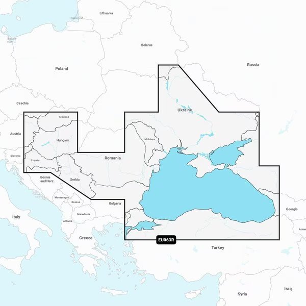
Navionics Vision+ NVEU063R, Black Sea Azov Sea, Marine Chart, Garmin, Mfr#: 010-C1258-00
$234.99
Free shipping will be applied on orders over $50
Navionics Vision+ NVEU063R - Black Sea Azov Sea - Marine Chart Get the world's No. 1 choice in the marine mapping with the best, most up-to-date Navionics+ cartography on your compatible chartplotter. Featuring vibrant colors, a streamlined interface and combined coastal/inland content with a popular Navionics style color palette, Garmin Navionics+ cartography makes it easy to plot your course. Multiple shading options aid in shallow water navigation and make it easy to highlight a target depth range for the best fishing spots. Fully customizable with various chart layers, overlay combinations and up to 10 color-shaded target depth ranges to scope out the best fishing spots. When you purchase a new Garmin Navionics+ or Garmin Navionics Vision+ cartography product, a one-year subscription is included. Chart Code - NVEU063R Coverage Area: Detailed coverage of the Dardanelles, the Sea of Marmara, the Bosporus Strait, the Black Sea, the Dnieper River to the Belarus/Ukrainian border, the Bug River to Nikolayev, the Kuban River to Krasnodar, the Danube River from its Vienna to its delta, the Sava River, the Danube - Black Sea Canal, Lake Balaton, Lake Ferto, the Tisa River to Lake Tisza and the Sea of Azov. Detailed coverage includes Varna, Constanta, Odessa, Nikolayev, Sevastopol, Mariupol, Taganrog, Temryuk, Novorossiysk, Batumi, Hopa, Samsun, Eregli, Istanbul and Canakkale. Features: All-in-one Map Solution - Access detail-rich mapping of coastal features, lakes, rivers and more. Integrated Garmin and Navionics content offers coverage for boaters worldwide. Daily Chart Updates - Charts are constantly being enhanced with new and amended content — as many as 5,000 updates are made every day. The one-year included subscription gives you access to daily chart updates via the ActiveCaptain app. Auto Guidance+ Technology - Combining the best of Garmin and Navionics automatic routing features, built-in Auto Guidance+ technology1 gives you a suggested dock-to-dock path to follow through channels, inlets, marina entrances and more. Depth Range Shading - High-resolution depth range shading lets you select up to 10 color-shaded options and view your designated target depths at a glance. Up to 1' Contours - For improved fis
Out of stock
You must be logged in to post a review.
Reviews
There are no reviews yet.